Eruption: How Human Development Is Degrading The American Serengeti
Big blowups: Stunning visuals from Google Earth show how private land development and resource extraction on public lands are harming wildlife in the Greater Yellowstone Ecosystem
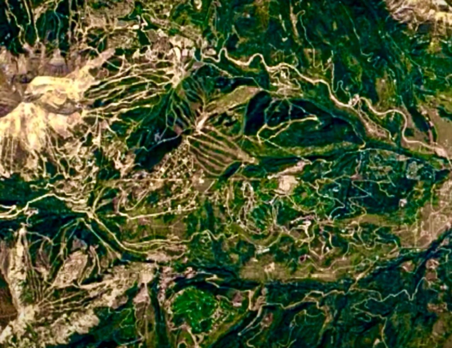
The human footprint of Big Sky, Montana as captured by GoogleEarth and satellite imagery between 1984 and 2020. Notably, the images do not include covid-related growth that generated more than $1 billion in real estate changing hands. Big Sky is located right in the middle of the otherwise wild and rugged Madison Mountain Range and its negative spillover affects are impacting the Gallatin River, the wildlife-rich Gallatin Mountains and potentially the Madison Valley which in winter is home of one of the largest migratory elk herds in the West.
by Todd Wilkinson
Population growth in the Greater Yellowstone Ecosystem—and, for that matter, many other locales where humanity intersects with still-wild natural landscapes—has been likened to a frog being slowly boiled in a pot of water, unaware that it’s being cooked to death.
The analogy seems especially apt. For people residing in a region like ours, the gradual, incremental impacts of growth may be imperceptible, while for others coming here, who knew special rural places generations ago and visiting it today, a return can be jarring. Make no mistake, not all corners of Greater Yellowstone have growing human populations nor are all recreation trails being inundated with record numbers of people.
But many are. And the negative transformations are not confined or contained; there are spillovers. Fueled by covid effect—large numbers of people trying to escape the pandemic by leaving urban areas for the public land hinters of the American West either relocating or coming on vacation—the pace of change has accelerated. Many planners in bustling towns and counties, many public land managers, many scientists, many conservationists and citizens concerned about the fate of the region’s famous wildlife, view the inundation as a wake-up call.
Not only is photographic imagery worth a thousand words; the truth that pictures tell, documenting the progression of the human development footprint chronicles not only the landscape-level impacts that already have happened, but their patterns portend what is yet to come—in the absence of a viable regional conservation strategy.
Thanks to a remarkable new feature from GoogleEarth called “Timelapse” and using satellite imagery, we are able to observe the dramatic progression of growth. In the videos assembled below, you can see how growth has picked up in speed and intensity. Worrisome to those trying to protect wildlife migration corridors for half a dozen species that remain intact in Greater Yellowstone and nowhere else in the Lower 48 to the degree they do here is what we don’t see. Yet.
Many agricultural lands—farms that grow crops and ranches with livestock, both of which provide crucial habitat and open space that defines Greater Yellowstone’s aesthetic ambiance and character, are subdivided. Platted for potential residential and commercial development, thousands of lots remain invisible, meaning that habitat which appears protected, may not be—unless it is safeguarded by a conservation easement.
Below is a selection of short video snapshots showing growth in and around Bozeman, Big Sky, and both sides of the Tetons in Jackson Hole and Teton Valley, Idaho. We also are including a progression of satellite photo stills taken of Yellowstone’s western boundary and a snippet of natural gas development in the Jonah Field south of Pinedale, Wyoming in the Upper Green River Basin near the southern end of the Wind River mountains.
Thanks to Gus O'Keefe for putting the footage together. With each video, we provide context:
Big Sky: Will The Bubble Of Lost Habitat Reach Madison Valley And Gallatin Range?
Nothing is more startling perhaps than the eruption of roads and buildings that has occurred around the once quaint ski resort town of Big Sky, Montana, bounded between the foot of Lone Mountain in the Madison Mountain Range on the west and US Highway 191 and the Gallatin River on the east.
Once upon a time, the valley where Big Sky exists today was a rural dell where livestock was grazed and where clearcut logging occurred on railroad checkerboard lands. The valley used to be a place known for its excellent hunting of wapiti—members of the famed Gallatin Elk Herd. It also used to be a crossroads for wildlife moving north to south through the Madisons and east to west between the Gallatin National Forest and the Madison Valley.
Imagine wildlife today having to navigate the labyrinth of development. A prime worry is what happens if the private Jack Creek Road, currently closed and allowing only limited use, is opened, providing a shortcut between Big Sky and Madison Valley where recently the Ennis Airport runway was expanded. (For context, see the video below showing development in Jackson Hole that coincided with extension of the commercial airport runway in Grand Teton National Park).
If air-traveling Big Sky residents were suddenly able to land in Ennis and not have to make the hour-long drive south from Bozeman-Yellowstone International Airport, it could be a game changing turn of events for Ennis and the Madison Valley.
As some conservationists say, if Big Sky were a hardrock mine, its negative impacts on wildlife, wildness and water quality in the Gallatin River would be considered an ongoing ecological disaster. But because it has morphed from being a relatively small ski destination in winter into a four-season resort, revolving around outdoor recreation and serving as a retreat for the wealthy and famous, it has not received the kind of intense scrutiny normally applied to natural resource extraction activities on public lands by environmentalists.
A looming question is: will Big Sky’s expanding appetite for outdoor recreation opportunity spill into the neighboring Gallatin Mountains to the east where one of the greatest assemblages of large mammal diversity still exists in a part of the Custer-Gallatin National Forest designated as a wilderness study area?
When All Of The Money In Teton County Still Can't Save Its Wildlife
Teton County, Wyoming is comprised of 97 percent federal and state land, with about three percent in private ownership, thus, the dynamic of strong demand meeting limited supply of developable land has resulted in skyrocketing real estate values. In fact, because of the gathering of affluent mostly second home owners, Teton County is one of the richest per capita, in terms of income in all of the US and few middle class professionals, be they teachers, cops, health care providers, federal employees, and business people can afford to buy a house there, causing a spillover across Teton Pass into Idaho (see video of Teton Valley below) and southward toward Hoback Junction and other communities.
The Jackson Hole Land Trust, a pioneering land trust in the West, has protected over 55,000 acres of wildlife habitat, open spaces and working lands (ranches) and, like all land-trust-like organizations in the region—including the Trust for Public Land, The Nature Conservancy and others—should be lauded for their accomplishments. That said, open space protection in Jackson Hole has come as a double edged sword. On the one hand it has preserved wildlife habitat and cowboy culture; on the other lands put under conservation easement are largely removed from consideration of possible development, including affordable housing. Read Justin Farrell's critically-acclaimed new book Billionaire Wilderness: The Ultra-Wealthy and the Remaking of the American West.
Plus, even while considering the important work of land trusts development pressure is overwhelming landscape protection, leaving behind pockets of open space which may, in the future, hold only marginal value for wildlife that can't get to them because of surrounding development.
In the forward simulation of satellite images below you can see the town of Jackson, Wyoming and how the pace of development moving westward toward the enclave of Wilson, toward the Snake River and southward into former ranchland has increased in recent decades. These days, in this area and on the west side of the Snake River between Wilson and Teton Village there has been an alarming number of wildlife-auto collisions resulting in animal roadkill.
Do Commercial Airports Doom Places Trying To Protect Nature From Bad Development?
What difference does ready access to a commercial airport make? When it comes to fueling population growth and land development, it has been a major catalyst both in Jackson Hole and Bozeman, both home to the busiest airports in their states. What will airport runway expansion in the Madison Valley and potentially in Teton Valley, Idaho mean for growth looking forward?
The Jackson Hole Airport is represented by the line in the middle of the video below just to the right and the long path of the Snake River to its left. The airport was granted a long-term lease enabling runway and facility expansion by former Interior Secretary James Watt in the early 1980s. It is the only major commercial airport located inside a crown jewel national park and its appropriateness has long been debated.
Many say the expansion of airport capabilities has been the singular factor in Jackson Hole's transformation into a destination for global jet setters and along with it skyrocketing real estate. What is the cost of prosperity?
Not only is the sound of jets landing and taking off in Grand Teton considered an intrusion into the normal tranquility that exists beneath the picturesque Tetons, but take note of how residential subdivision proliferates south and southwest of the airport and even on the west side of the Snake River.
Such development, conservation biologists say, has had a major deleterious impact on the movement of large mammals on private lands in the valley, serving as a marked contrast to protected public lands in Grand Teton apart, of course, from the presence of the airport.
Teton Valley, Idaho: Now In The Crosshairs Of Growth-Driven Change
Teton Valley, Idaho rests on the western side of the Tetons opposite Jackson Hole on the eastern side and has been distinguished not only for its spectacular views of the mountains but its agricultural heritage.
The lack of affordable housing in Jackson Hole has resulted in plenty of refugees seeking to find cheaper homes and rents in Idaho but commuting daily back to Jackson Hole for work. Displaced Jackson Hole residents are fueling growth issues in Teton Valley along with well to do people who own second homes and newer covid-related transplants moving in.
Now there is a proposal to markedly expand Grand Targhee Ski Resort east of Driggs and many Teton Valley residents are worried it will follow the ecologically-insensitive path of Big Sky, Montana, which does not bode well for wildlife habitat on private land and on public land if they come under a tidal wave of outdoor recreationists.
Teton Valley is an important corner not only of Greater Yellowstone but the “High Divide Ecosystem” that extends into the Bitterroot Mountains and wildlands in central Idaho.
At present, multi-generation farming families remain on the land but with land developers dangling enormous sums of money in front of patriarchs and matriarchs who are at retirement age or older, and their offspring reluctant to carry on the hard work of their elders, many believe Teton Valley is on borrowed time. The local Teton Regional Land Trust is active and so is Valley Advocates for Responsible Development, which along with the Jackson Hole Conservation Alliance, the Park County Environmental Council and Friends of Park County in Montana are the most tenacious watchdogs of land use planning in the ecosystem.
Can they convince local county commissioners to embrace planning and zoning and realize that poorly orchestrated development is a recipe for fiscal crisis, rising taxes and exploding costs of services? They face a David vs. Goliath battle. In the video below, you can see Driggs which is the epicenter of population growth and the west side of the Tetons on the right.
In Bozeman and Gallatin County, Montana, Wildlife Migrations On Verge Of Being Lost
Bozeman, Montana is the fastest-growing micropolitan (small city) in America and Gallatin County, Montana that encompasses Bozeman and the surrounding landscape is one of the fastest growing rural counties in the West.
As Mountain Journal has reported, based on analysis from professional planners, Bozeman/Gallatin will double in population by around 2040 to be the present size of Salt Lake City (the size of the city, not the entire metro area). And, if the pace of arriving newcomers holds or increases, the population could double again by around 2060, meaning it would have the current population of Minneapolis proper (420,000 people).
With a cultural shift underway as people fleeing crowded metropolises are able to work from home, and plan ahead to escape disruptions caused by climate change—extreme heat in the desert, water shortages in the West, storm related damage along the ocean coasts and wildfire in California—demographers say the above projection is well within the realm of possibility.
Even without such incendiary growth occurring, there is a looming possibility: the lack of a strategy for containing sprawl already is leading to rapid landscape fragmentation in the valley encircling Bozeman. One indicator: Within a few years the elk migration that moves across the southern Gallatin Valley between the Gallatin mountains across busy US Highway 191 westward to Ted Turner’s 113,000-acre Flying D Ranch (protected by a conservation easement with The Nature Conservancy) could cease to exist.
Another entity working on private land protection is the Gallatin Valley Land Trust (GVLT) which, since 1990, has collaborated with over 93 families to conserve 43,000 acres of land in southwest Montana via conservation easement. Unfortunately, GVLT is out-financed and outmatched by a juggernaut of developers who have taken advantage of lax planning and zoning long supported by Gallatin County's elected officials.
The GoogleEarth video below demonstrates how leapfrog development has rapidly expanded westward and southward from Bozeman into the county like a wave toward Four Corners, across farm land that has some of the finest soils for growing crops in the state and crucial wildlife winter range. A similar pattern, not seen, is occurring from Bozeman and extending toward Belgrade and beyond and just north of Bozeman along the western face of the Bridgers.
Some Call Gallatin County The Poster Child Of Poor Land Use Planning
This second video of the Gallatin Valley, below, shows a quickening of development just north of the Gallatin Mountains extending west to the mouth of Gallatin Canyon and northwestward toward Gallatin Gateway. Ironically, one of the major developments now happening is a complex of affordable housing for workers in Big Sky who cannot afford to live there and make a daily 70-mile roundtrip commute. Many find it strange that in order to accommodate more construction and to house service workers in Big Sky, more of the agrarian Gallatin Valley and its wildlife resources will be negatively affected.
If you look closely you can also see development that lines both sides of the Gallatin River. The open space demarked by geometric and circular green patterns today is being transformed into essentially a giant suburb with remnants of both the pastoral character of the land and wildlife moving through it disappearing. Dozens of elk trying to cross US 191 south of Gallatin Gateway have been killed by vehicles in recent years.
Today, seeing the changes occurring, some longtime Bozeman/Gallatin residents are packing up and leaving, heading for towns like Dillon, Lewistown and even Butte. Another nearby place on the verge of facing unprecedented development pressure: Livingston and Park County on the other side of Bozeman Pass. As one well-known planner told Mountain Journal, you don't begin thinking about growth impacts only when you reach a crisis, you identify the trends and try to prevent the worst effects from happening.
Forests Can Grow Back, But Sprawl Is Forever
Development, residential subdivision, human infrastructure and sprawl are forever when it comes to leaving permanent scars, lacerations and fragmentation on private lands in Greater Yellowstone. As conservation-minded planners like to say, “no subdivision has ever gone away.”
But not all of the trends of landscape modification have been permanently cemented. Natural resource extraction, even industrial-strength clearcut logging can occur but forests, if given time and having nurturing help from weather and climate, can eventually grow back.
Take a look at the center of the video below and you will see a hard north to south line that delineates the western border of Yellowstone National Park on the right and the Caribou-Targhee National Forest on the left. A massive campaign of logging was carried out in the 1980s as a strategy promoted by federal foresters and the timber industry to combat an outbreak of pine beetles.
In fact, a photograph taken from space showing how logging pressed right up against Yellowstone, with little mind given to the negative impacts on elk, moose and imperiled grizzly bears, became a rallying cry for environmentalists to challenge timber sales throughout the ecosystem. Another negative side effect of the logging program on the Caribou-Targhee were hundreds of miles of logging roads, which increased human access and brought not only further fragmentation of degraded habitat but poaching problems because lawless individuals had ready access.
As a result of a massive re-forestation effort on the Caribou-Targhee and closure of old logging roads, habitat for wildlife has recovered, showing the resilience of nature if given a chance. Indeed, today, there is a continuous swath of green between Yellowstone and the adjacent national forest—also a testament to how far ecosystem has evolved since the 1980s and the recognition that ecological stewardship does not begin or end along an artificial human-made boundary.
An Energy Boom That Has Come At Great Cost To Wildlife
Between them, the Jonah natural gas field and gas development on the Pinedale Anticline have been the poster children of what not to do when it comes to claiming to protect wildlife and natural resource extraction as permitted by the federal Bureau of Land Management. Energy development has generated billions of dollars in revenue for private drillers and the state, but it also has disrupted the migration of pronghorn, mule deer and the nesting and wintering areas of imperiled Greater Sage-Grouse.
In some areas, mule deer numbers declined by 40 percent when faced with the gauntlet of intensive natural resource extraction. You can see how just a small sliver of energy development rapidly expands creating sacrifice zones for wildlife. Extrapolate its impact at scale. The upshot, however, is that eventually, after the last natural gas is extracted, these public lands can be healed and restored, provided, of course, that wildlife populations can hang on until it happens.
MOJO NOTE: Mountain Journal brings you stories you won't find anywhere else! What's the value of that in your life? Please consider supporting us by participating in the NewsMatch program available to journalistic non-profits creating content in the public interest. We profoundly appreciate your generosity in helping us protect the Yellowstone region with facts. You can do that by clicking here. Every contribution, up to $1,000, will be matched dollar for dollar!
Make sure you never miss a a storyby signing up for Mountain Journal's free weekly newsletter. Click here: https://bit.ly/3cYVBtK
About Todd Wilkinson
Todd Wilkinson, founder of Mountain Journal, is author of the book Ripple Effects: How to Save Yellowstone and American's Most Iconic Wildlife Ecosystem. Wilkinson has been writing about Greater Yellowstone for 35 years and is a correspondent to publications ranging from National Geographic to The Guardian. He is author of several books on topics as diverse as scientific whistleblowers and Ted Turner, and a book about the harrowing story of Jackson Hole grizzly mother 399, the most famous bear in the world which features photographs by Thomas Mangelsen. For more information on Wilkinson, click here. (Photo by David J Swift).