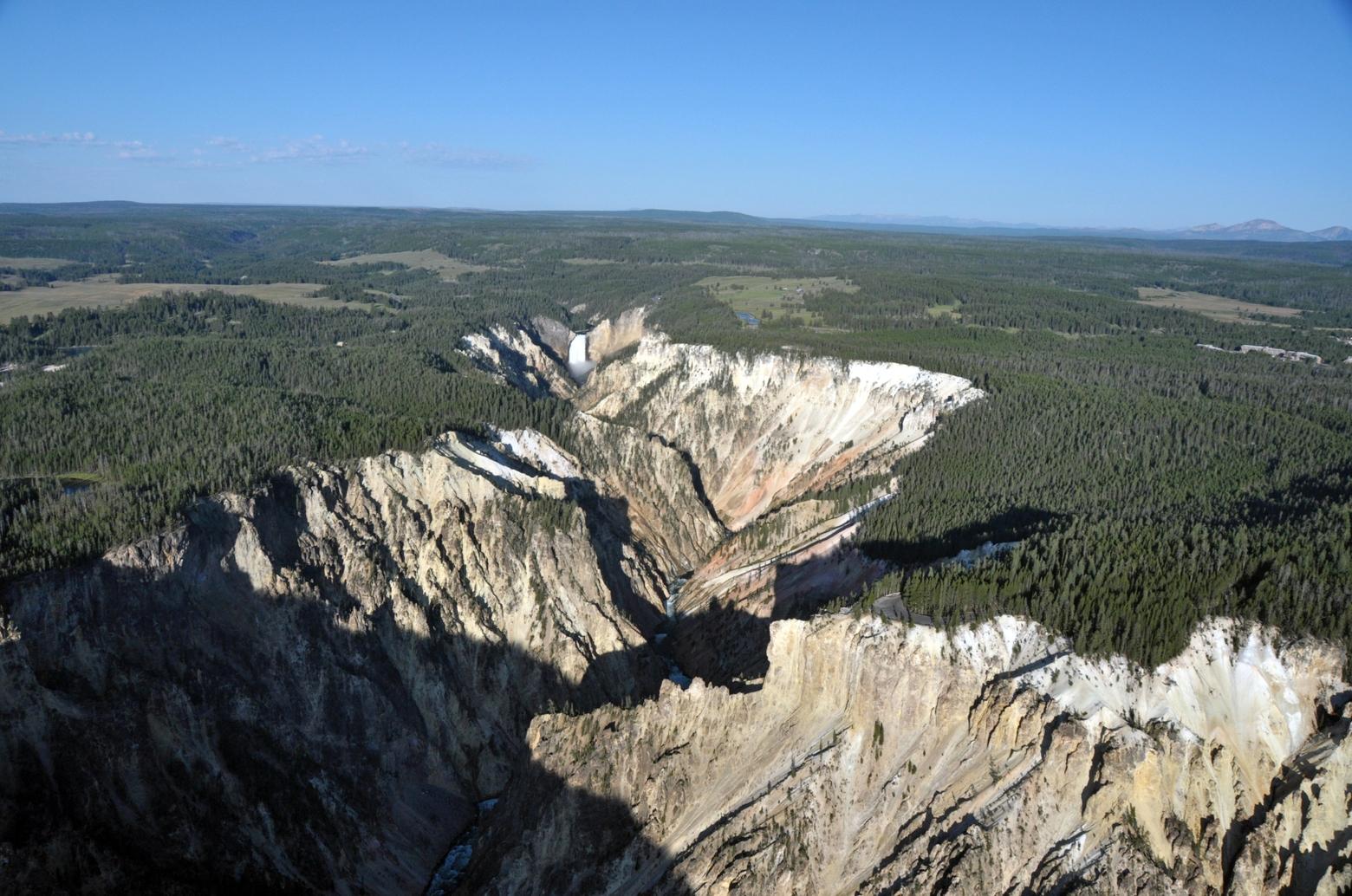
Lower Falls of the Yellowstone River and the Grand Canyon of the Yellowstone, photographed during a helicopter flyover in August of 2019. Photo by Michael Poland
by Michael Poland
Yellowstone Volcano Observatory
EDITOR'S NOTE: Yellowstone Caldera Chronicles is a weekly column written by scientists and collaborators of the Yellowstone Volcano Observatory. This week's contribution is from Michael Poland, geophysicist with the U.S. Geological Survey and Scientist-in-Charge of the Yellowstone Volcano Observatory.
The Grand Canyon of the Yellowstone is a natural wonder that almost defies description. The reaction of explorer Charles Cook when he first viewed the canyon in 1869 seems appropriate: “I sat there in amazement, while my companions came up, and after that, it seemed to me that it was five minutes before anyone spoke."
Stretching from the Lower Falls to the Tower Falls area, the Grand Canyon of the Yellowstone is about 17 miles long, 820–1,150 feet deep, and 1,500–4,000 feet across. It appears to be a surprisingly young feature of the region, having mostly formed during and immediately following the last ice age, within the past 20,000 years or so. The geological story of the canyon, however, begins immediately after the formation of Yellowstone Caldera.
Approximately 631,000 years ago, the most recent massive explosive eruption evacuated so much magma that the ground collapsed to form a giant crater called a caldera. Soon after, magma began refilling the subsurface chamber, pushing the ground surface upward and forming “resurgent domes” on the east and west sides of the caldera. This uplift resulted in the creation of many faults, including some in the area of the future Grand Canyon of the Yellowstone.
“I sat there in amazement, while my companions came up, and after that, it seemed to me that it was five minutes before anyone spoke."
– Charles Cook, Yellowstone explorer
The next major geological activity in the region was the eruption of flows of rhyolitelava and some ash some 480,000 years ago. These lava flows are not like those in Hawaii, but instead are many hundreds of feet thick, and they flowed very slowly. Following the eruption of the lava, hydrothermal activity began to take hold in the region, with gases over 300 F in temperature channeled into the area. These gases rose to the surface along the faults that formed because of the resurgent doming.
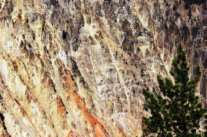
By about 150,000 years ago, the area was the site of a vigorous acid-sulfate thermal area that might have looked a bit like the Mud Volcano region looks today, with boiling mud pots and fumaroles emitting sulfur gases and other compounds. We know this from looking at the rocks
Closeup of a wall of the Grand Canyon of the Yellowstone showing red, orange and yellow mineral alternation, as well as white veins of silica, in the subsurface alteration zone of a former thermal basin. Photo by Pat Shanks
There might have been a small valley in the area at that time due to erosion by the Yellowstone River, but it likely wasn’t deep. Certainly, it was not yet “grand,” but the stage was set.
By 22,000 years ago, a thick ice cap covered Yellowstone as part of the Pinedale glaciation. As those glaciers began to retreat, it is possible that an ice dam formed somewhere near Yellowstone Lake, causing water to temporarily back up. A similar ice dam during the previous Bull Lake glaciation, about 150,000 years ago, near the Canyon area resulted in the formation of a lake that today is marked by Hayden Valley. The Pinedale ice dam could have failed and reformed repeatedly between 18,000 and 14,000 years ago, releasing torrents of water that caused rapid erosion of the canyon. It is also possible that the canyon was scoured, in whole or in part, by sudden outbursts from Yellowstone Lake after the ice was gone. There is evidence from geological deposits that earthquake-triggered tsunami have occurred on the lake, causing large flows of water down the Yellowstone River.
Regardless of the source, we know that it was flooding by water, and not erosion by glaciers, that created the canyon because of the feature’s V-like shape (glacial canyons have U-like shapes). The area of the present canyon was especially susceptible to erosion because of the presence of the faults and widespread hydrothermal alteration, which weakened the rock. These faults and the contrasts between the weak canyon rocks and stronger rocks upstream control the locations of the Upper and Lower Falls today.
The story of the Grand Canyon of the Yellowstone is the story of the region itself: of massive explosions, uplift and faulting of the ground, thick lava flows, abundant hydrothermal activity, massive glaciers, and raging rivers.
About Michael Poland
Michael Poland is a geophysicist with the U.S. Geological Survey and Scientist-in-Charge of the Yellowstone Volcano Observatory.