In this op-ed, a former hydrologist writes that bison are destroying streams in Yellowstone National Park. Here’s what he says the Park Service should do.
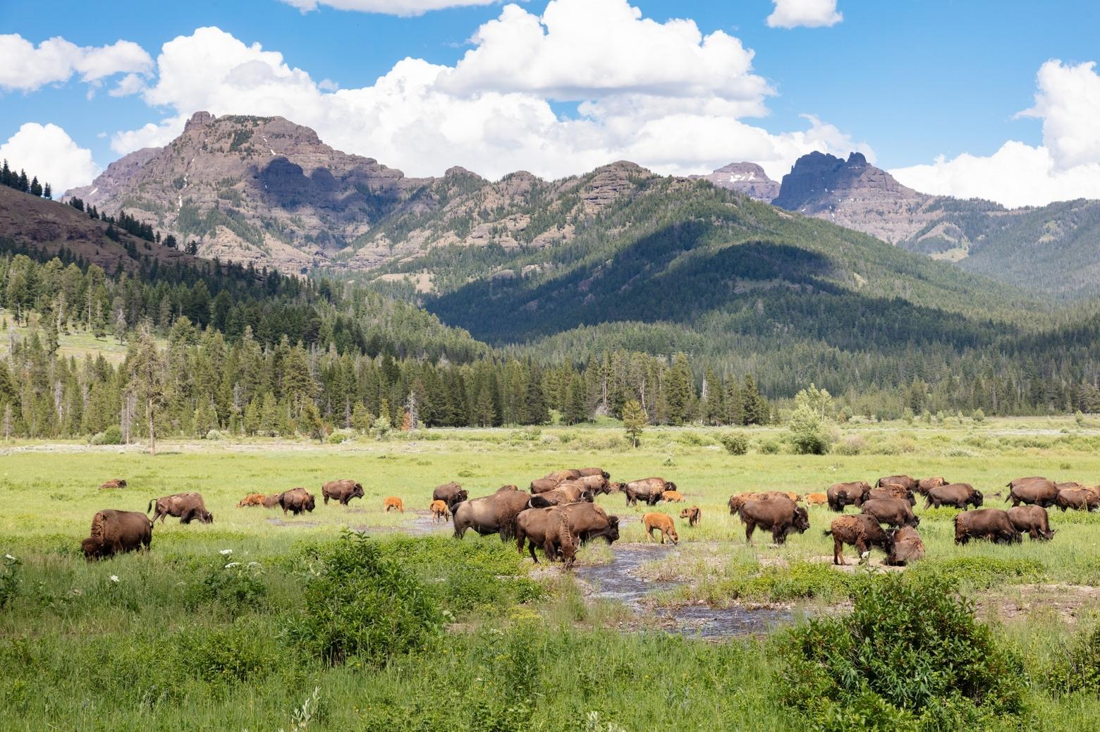
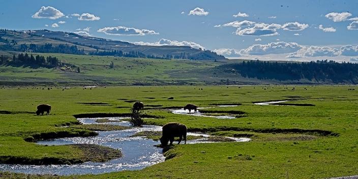
While large bison herds may be popular with tourists, they are damaging streams and streamside vegetation throughout the Lamar Valley. Photo by Jacob W. Frank/ NPS
by Pete Bengeyfield
The
National Park Service recently released its environmental impact statement
concerning the numbers of bison they will manage for in the future. Its
“preferred alternative” calls for between 4,500 and 6,000 bison in Yellowstone
National Park. When bison numbers reach 6,000, NPS will initiate control
actions, mainly tribal and state-sponsored hunts, to keep the herds at that
level.
But
there’s a problem: the current numbers of bison, which NPS puts at 4,450 before
bison calves were born in spring, are irreparably damaging the streams and
riparian areas on the Northern Range to such an extent that they can no longer
preform the “job” they evolved to do within the larger landscape. Basically, it
boils down to having too many hooves in too small an area for too long a time.
Many
people take streams for granted: they are always there, they move water
downhill, fish live in them. In reality, it’s a little more complex. The job of
a stream is to collect and distribute the most precious resource in the West: water.
In so doing, they’re constantly adjusting their dimension (cross-section),
pattern (crookedness) and profile (steepness) to reflect changing conditions in
their watershed and achieve stability. When changes are small as in the case of
tectonics and, until recently,
Bison grazing near streams in Lamar Valley are causing damage to riparian zones. Photo by Pete Bengeyfield
climate, the stream reacts slowly. But the
response is much quicker when the changes occur to the channel itself. There is
always room for some change—most resources work on the concept of thresholds—if
change occurs up to the threshold, systems remain stable. If the threshold is
exceeded, however, things unravel quickly.
Federal
land-management agencies practice something called “ecosystem management” with
regards to their wild lands. The term most used to describe the target of EM is
“function,” or whether a resource is performing the role it evolved for. In
other words, is it doing its job? The idea of EM is to maintain all components
of an ecosystem in a functioning condition, so the larger ecosystem remains
functioning. Undisturbed ecosystems achieve a stability that tends to last a
long time, and the ecosystem responds slowly to changes in climate and geology.
In the 12,000 years or so since the end of the Pleistocene epoch, the streams
of Yellowstone’s Northern Range have reached a level of stability within the
landscape that enables them to perform their functions with efficiency.
Ask
most people what their idea of what stream/riparian function is, and they will
mention habitat for everything from fish to moose. While that is true, habitat
is a secondary benefit of a functioning stream. Streams arephysical systems firstand
must meet three physical conditions to achieve function: 1) move water and
sediment through the system in the most efficient manner, 2) make use of their
floodplain, and 3) recharge the local water table. All three are closely tied to the maintenance of riparian
vegetation—mainly willows and sedges—which is necessary to hold the streams
together by virtue of their dense root systems.
The job of a stream is to collect and distribute
the most precious resource in the West: water.
In
the EIS and in “The Grazing Issue” of the NPS-published journal Yellowstone Science, park scientists explain
that forage is not a limiting factor in determining bison numbers. There is
indeed enough forage to support expanded levels of bison on the Northern Range,
but that is totally irrelevant to the situation on the ground. For when all the
resources are forced to interact on the same landscape, other limiting factors
come into play.
In
the case of the Northern Range, the limiting factor is the collateral damage
done to streams/riparian areas as bison are using the available forage. It has
nothing to do with “grazing” per se. It is the trampling of streambanks, and
the subsequent widening of the channel, that leads to the downward spiral preventing
streams from achieving function.
Of
all the components of a stream—width, depth, slope, streamflow, sediment size,
sediment load, sinuosity—stream width is the easiest to change.As a stream widens, the water spreads
out and the velocity of the water drops. This drop in velocity prevents the
stream from carrying its sediment load. In turn, gravel bars, or deposited
sediment, form within the confines of the widened banks. Since it is always
easier for a stream to erode its banks than to pick up instream sediment, the
streamflow must bend around the gravel bars, thus causing more bank erosion and
further widening. A wider channel has a larger cross-section, and it takes more
water to fill the channel and spill over onto the floodplain.
As
floodplain inundation becomes less frequent, the water table dries out and
riparian vegetation, with its critical root systems, is replaced by upland
species such as sagebrush and bunchgrass. Where a stream is on this continuum
depends on how much disturbance it has received, but from what I have seen on
the Northern Range, most streams are well on their way along the downward
spiral that leads to non-function—some are there already—all because of bison
widening the stream.
The
point is that once the stream becomes over-widened, it is at the mercy of both
the physics of sediment transport and of flowing water. The photos below show
this. To see it in the field, compare Rose Creek in the Lamar Valley with Glen
Creek on Swan Lake Flats.
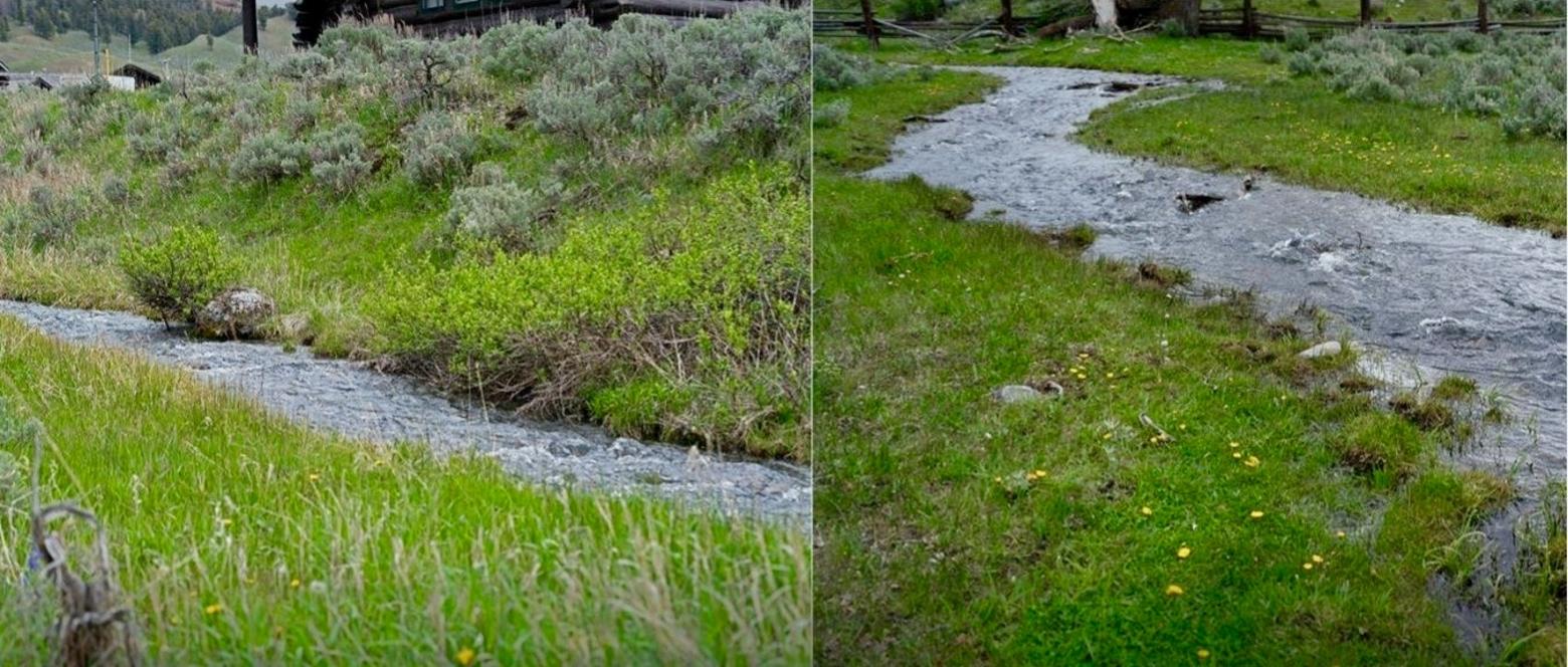
Rose Creek adjacent to the Lamar Ranger Station. At left is a section of stream not trampled by bison because it is inside the fence surrounding the station. Note the narrow channel, defined banks and the willows along the stream. The photo at right is below the fence. Note the wider channel and the hoof marks along the banks of the stream. This is how streams become over-widened. Photos by Pete Bengeyfield
Of
course, the elephant in the room in all this is climate change. Most
predictions are for a warmer and drier West. The best hedge against climate
change is functioning streams and riparian areas. Riparian areas act as big
sponges that collect and store water early in the season and then release it
slowly later in the year. Water not stored because riparian areas are not
functioning properly is lost to late-season downstream users such as irrigators
and municipalities. The EIS makes no mention of this function of riparian
areas.
So,
what to do? I see this bison issue is analogous to the wolf project—perhaps the
most successful thing Yellowstone National Park has ever done. There is a
current crisis on the ground that requires out-of-the-box thinking to solve.
The solutions may go against Park Service dogma, but the problem is too large
to solve any other way.
The
first thing to do is to maintain or increase bison removal to reduce herd size
to a point that streambank trampling is no longer a problem. The so-called
“hunt” is both unfortunate and necessary. It should be expanded. Once numbers
are reduced, restoration of damaged streams and riparian zones could begin. I
would line these channels with willows and sedge mats to the desired stream
width. Then, after a few years, reintroduce beaver—another species whose function
has been removed from the ecosystem—to the same streams.
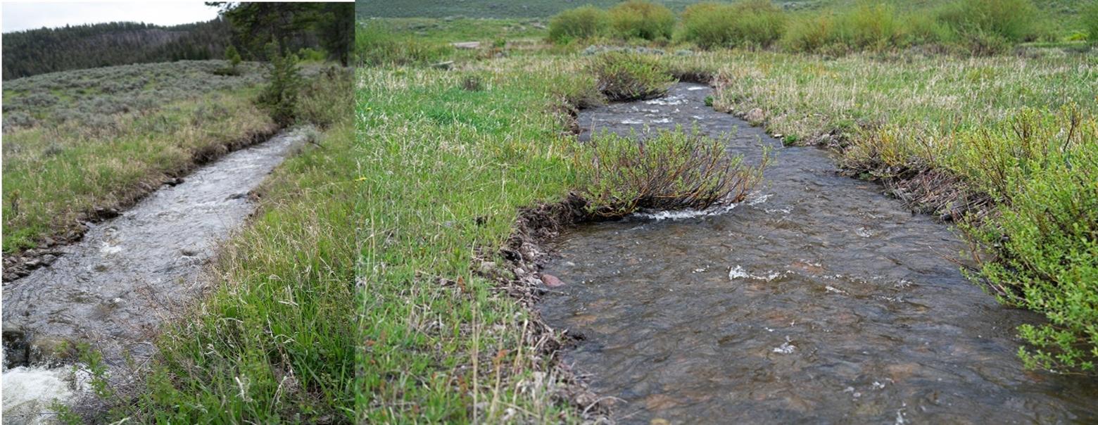
Lost Lake Creek, adjacent to the Tower Ranger station. Above the road (left), there is some trampling, but the stream has retained its cross-section and is still functioning. Below the road (right), hoof marks are visible along both banks and the stream has over-widened considerably. Once the stream cuts behind that willow clump, widening will increase even more. Photos by Pete Bengeyfield
Concurrently
with restoration, the Park Service could be looking for places to introduce
bison. One example would be the Gravelly/Snowcrest/Centennial complex on the
Beaverhead National Forest. Abutting Greater Yellowstone to the west, the area
is roughly 85 percent under federal management today. The habitat for bison is
as good as the Northern Range, and there is about three times more of it. So, solutions
exist. The wolf project was a bold decision that produced outstanding results.
We need more of that kind of thinking.
For
a federal flagship agency such as the National Park Service to do an EIS on any
grazing issue and not include a discussion on streams and riparian areas is
puzzling to say the least. There was no riparian expertise on the team that put
the document together, but they merely had to approach one of the surrounding
national forests and ask how they’ve dealt with riparian issues.
As
it stands now, the “Effects” section of all the alternatives should read
something like this: “Due to bison trampling streambanks, tributary streams to
the Lamar River will cease to perform their hydrologic function because of
stream over-widening, lack of bedload transport, a shift in riparian vegetation,
and lack of floodplain access. More bank erosion will occur, and sediment loads
to the Lamar River will increase. Water storage in the riparian areas will
diminish, causing late-season flows to be affected. There will be a loss of
both terrestrial and aquatic habitat for riparian-dependent species.”
If
the Park Service chooses to favor one resource—in this case bison—over another—in
this case streams/riparian zones—that’s not Ecosystem Management. That’s
playing God in Yellowstone.
Pete Bengeyfield worked for 32 years
as a hydrologist for the state of Montana and the U.S. Forest Service. He spent
the last 22 years on the Beaverhead National Forest, on the western edge of
Greater Yellowstone, working on grazing issues.