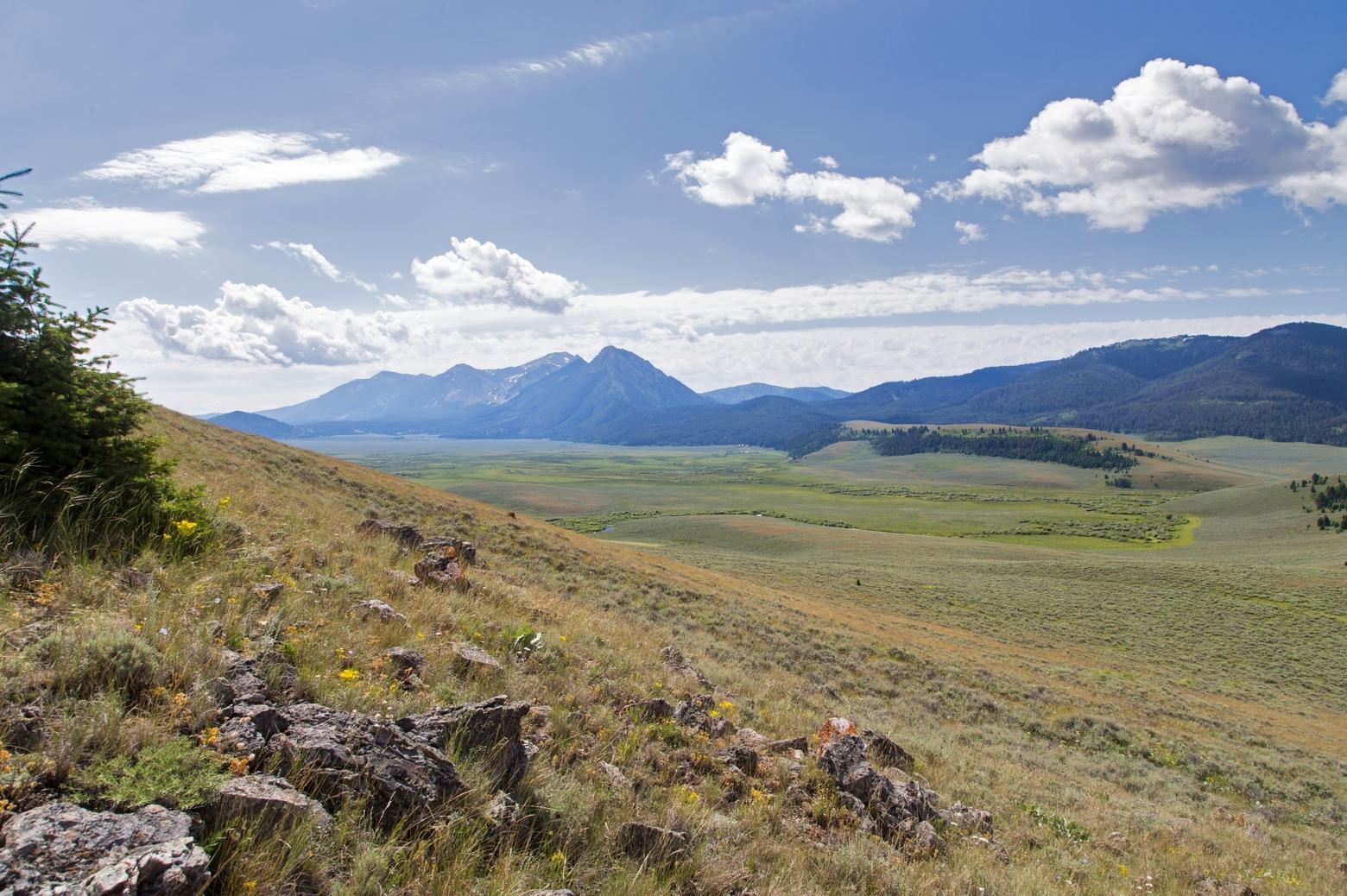
The Alaska Basin addition to the Red Rock Lakes National Wildlife Refuge in the Centennial Valley encompasses more than 53,000 acres, including 32,350 which are designated wilderness. Photo courtesy USFWS
by David
Tucker
Deep in Montana’s
southwest corner, a windswept steppe and rolling sagebrush sea provide critical
habitat for iconic species like pronghorn, sage grouse and arctic grayling. This
landscape is also home to large-scale, multi-general agricultural outfits that
face mounting economic and social pressure as markets shift and land use
changes. It’s here that the U.S. Fish and Wildlife Service has proposed the Missouri Headwaters Conservation
Area, a regional effort
to protect this landscape from the subdivision and sprawl seen elsewhere in Greater
Yellowstone.
The High
Divide, as this area is commonly called, is a sprawling mosaic of working
ranches, family-run agricultural operations, state and federal public lands and
private conservation easements. By stitching together up to a quarter-million
acres of this special landscape, the Service hopes to further protect threatened
wildlife and safeguard precious water resources, all while allowing agricultural
operators to continue doing business.
“Subdivision
for residential development is the number one threat,” said David Allen, realty
specialist with USFWS, “and the species that the agency is focused on all
currently exist on this landscape. Movement corridors are there and in place
largely thanks to the stewardship of private landowners managing working
ranches that have tremendous benefit for wildlife.”
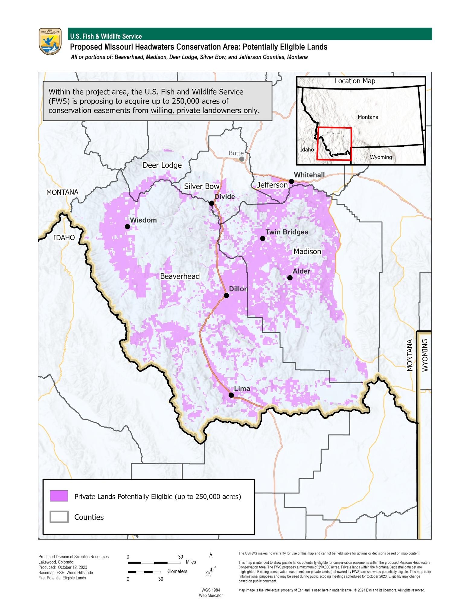
The
boundaries of the Missouri Headwaters Conservation Area, as currently proposed
by the Fish and Wildlife Service, would stretch from the Madison Valley in the
east, north to I-90, west to the Beaverhead Mountains and south to the
Centennial Range. While the entire
landmass being considered is roughly 5.7 million acres, much of it is already
managed by federal agencies or fails to meet program criteria, leaving about
1.6 million eligible private acres.
Map courtesy USFWS
Of those
1.6 million acres, USFWS is proposing to set a goal of 250,000 acres under conservation
easement over a multi-decade timeline. The Land
and Water Conservation Fund
would provide most of the necessary funding. “Conservation Areas have a very
specific meaning,” Allen said. “They give us the ability to work with willing
landowners to purchase conservation easements. They don’t limit mineral rights
or access, and include no further regulation. We just want [landowners] to keep
doing what they’re doing.”
Across
Montana, four USFWS Conservation Areas exist already—the Rocky Mountain Front,
the Swan Valley, the Lost Trail in northwest Montana and the Blackfoot Valley. “Easements
are perpetual, protected under property law,” Allen said, “and as new
challenges to wildlife and habitat conservation have emerged, our easement
program has adapted and diversified to meet these challenges. Conservation
Areas have proven to be an effective approach to conserving fish and wildlife
habitat.” Once a Conservation Area is established, it becomes a unit of the
National Wildlife Refuge System, although any included lands remain private
property and activities currently allowed there can continue, Allen added.
While the Missouri
Headwaters Conservation Area could add significant acreage under easement, it
is hardly the only regional effort aimed at the preservation of working
landscapes that benefit wildlife and other natural resources. “[The Nature
Conservancy] established our High Divide Headwaters program in 1998,” said
program director Jim Berkey, “and TNC currently holds 66 conservation easements
in the High Divide totaling just over 265,000 acres.” By partnering with
willing landowners, “TNC has piloted innovative habitat restoration approaches,
especially in riparian and sagebrush systems, on both private and public
lands,” Berkey said.
“The more these landowners can benefit from this, while simultaneously protecting the landscape, protecting the wildlife that live there—to me it’s just a win-win.” – Chad Klinkenborg, southwest manager, Montana Land Reliance
As is so
often the case, partnership, collaboration and networking has been critical to
success. “Since 2017, we have served as a lead for the Southwest Montana Sagebrush
Partnership, a
coalition of public land management agencies, watershed groups and landowners
that has greatly increased the pace and scale of restoration work addressing
key threats to southwest Montana’s sage steppe,” Berkey continued. “We face two
big challenges; economic forces—land values, commodity values—that threaten
family-based working ranches, the operations that steward our most productive
valley-bottom lands that tie public lands together and also sustain our rural
communities. And environmental forces like drought, cheatgrass and wildfire that
challenge the resilience of our natural and social systems.”
“We’ve
been working in this landscape for quite a while and are contacted by a lot of
landowners who are interested in conservation projects, including easements,”
Berkey said. “We have a pretty good sense of demand as time has moved on and
that’s been on the increase. That interest in easements far outstrips what we
can do, both from what we have a capacity to do as staff, but also what funding
resources we can tap into.”
A USFWS
Conservation Area would expand the pool of available funds to include allocations
from the Land and Water Conservation Fund, and Chad Klinkenborg of Montana
Land Reliance is
optimistic about that potential financial tailwind. “By bringing more funding
into the landscape, it gives landowners another tool and another organization
to potentially partner with to monetize their private property rights,”
Klinkenborg said. “It brings more funding to southwest Montana and it brings
more opportunities for landowners to utilize, if they want to.”
“To me
it’s a positive,” he continued. “The more these landowners can benefit from
this, while simultaneously protecting the landscape, protecting the wildlife
that live there—to me it’s just a win-win.”
With a
public scoping period concluding on November 27, Allen says now is the time to review the proposal and submit public comment. “We’re
in the early stages,” he said. “And this is just one piece of the puzzle—it’s
going take a variety of solutions and efforts.”
Mountain Journal is the only nonprofit, public-interest journalism organization of its kind dedicated to covering the wildlife and wild lands of Greater Yellowstone. We take pride in our work, yet to keep bold, independent journalism free, we need your support. Please donate here. Thank you.
About David Tucker
David Tucker is a freelance journalist covering conservation, recreation and the environment in the Greater Yellowstone Ecosystem.